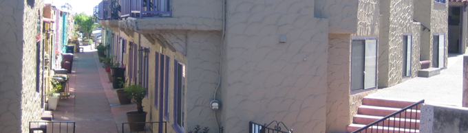
2011, Bridgette Land Surveying prepares Elevation Certificates and Letter of Map Revision (LOMR) at the Capitola Venetian Hotel, Capitola, California
This is a partial list of current and completed projects by Bridgette Land Surveying.
Residential
Commercial
Industrial
Institutional
Municipal
Residential Projects
- Adanalian, Steve – Minor Land Division at Calabasas Road, Watsonville
- Bartfield Motel Group – Baron Court & Blackburn Court, Watsonville – Elevation Certificates
- Kasprow, Mark – Tindall Ranch - Boundary Surveying with Easement Design, Legal Description and Mapping
- Belveal, Dan – 15 acre Boundary Survey in Saratoga
- Covarrubias, Fidel – 23 Lot Subdivision in Salinas
- Denuccio, Kevin – GPS Boundary Surveying at Summit Road, Watsonville
- Smith, Bruce – Boundary Surveying, Monumentation and Record of Survey at Carmel Highlands
- Quinn, Michael – Boundary Survey, Monumentation and Record of Survey, Aptos
- Easy Access Developers – Camphor Commons – Condominium Subdivision, Santa Cruz
- Easy Access Developers – Boundary Surveying and Construction Staking at Keystone Avenue, Santa Cruz
- Easy Access Developers – Parcel Map at Felix Street, Santa Cruz
- Dirksen, Trevor – Boundary Survey, Topographic Survey and Roof Height Certification Survey at Vista Del Mar, Aptos
- L&D Construction – Via Del Mar Housing Project, Watsonville – Multi-Floor Staking
Commercial Projects
Commercial Projects
- Barry Swenson Builder – Goodwill Industries, Capitola – Parking Lot Construction Staking
- Barry Swenson Builder – 207 Church Street Project – Parking Lot and Utilities Construction Staking
- Barry Swenson Builder – Second Harvest Food Bank – Boundary Surveying, Record of Survey, Building Additions, Utilities, Curb & Gutter, Loading Dock and Parking Lot Construction Staking
- Barry Swenson Builder – Bicycle Trip – Parking Lot & Utilities Construction Staking
- Barry Swenson Builder – Dream Inn – Restaurant Addition and Parking Lot Construction Staking
- Dr. Hurray, Capitola – Boundary Survey for Parcel Size and Density
- Pajaro Dunes Association – New Office Building Elevation Certificate.
- BK Properties – Mission Street Commercial Building – Building, Utilities and Curb & Gutter Construction Staking
- Seldon and Son – Romo Enterprises Watsonville – Building Construction Staking
- Easy Access Developers – Pacific Inn, Santa Cruz – Boundary Survey, Building and Utilities Construction Staking
Industrial Projects
Industrial Projects
- Driscoll Strawberry, Salinas - 30 acre Boundary Survey
- Taussig, Kelsey – Tindall Ranch Vineyard – Lot Line Adjustment Surveying
- Couch Distributing, Watsonville – Boundary Survey with Site Plan, Building Addition and Parking Lot Construction Staking, Elevation Certificate
- MFJK Partnership, Moss Landing – Agriculture Lot Line Adjustment, Monumentation and Record of Survey
- B&H Flowers – Freedom Boulevard Ranch Boundary Survey
- B&H Flowers – San Andreas Road Ranch Boundary Survey
- Pini, Aldo – Agriculture Minor Land Division at Pini Road
Institutional Projects
Institutional Projects
- Monte Vista Christian School – Campus Master Plan – campus wide surveying and mapping using GPS, robotic total station and photogrammetry
- Monte Vista Christian School – New Gymnasium and Chapel Topographic Surveying and Mapping
- Monte Vista Christian School – Football Stadium Construction Staking
- Monte Vista Christian School – Boundary Survey, Monumentation and Record of Survey
- Monte Vista Christian School – Gymnasium Construction Staking
- Monte Vista Christian School – Middle School Topographic Surveying and Construction Staking
- Pacific Grove Adult Education – Building Construction Staking
- Pajaro Valley Unified School District – Freedom School "Headstart Program" Topographic Survey
- Aptos High School – Walkway and Stairs Topographic Survey
- San Lorenzo Valley Junior High – Buildings Construction Staking
- Notre Dame School – Buildings and Parking Construction Staking
- Ridge Runner Motorcycle Club – 80 acre Boundary Survey utilizing GPS and robotic total station, Record of Survey
- Camphill Communities Soquel – Boundary Survey and Utility Easement Design and Mapping
- Sacred Heart School, Salinas – Building, Utilities and Concrete Walks Construction Staking
Municipal Projects
Municipal Projects
- City of Santa Cruz, Water Dept. - Lab Expansion, Graham Hill, Construction Staking
- County of Santa Cruz, Public Works - 7th & Brommer Sanitary Sewer Topographic Survey
- County of Santa Cruz, Public Works - Pleasure Point Sanitary Sewer Topographic Survey
- County of Santa Cruz, Public Works - Mattison Lane Right of Way Establishment, Monumentation and Record of Survey
- County of Santa Cruz, Public Works - Pajaro River Levee Monumentation
- County of Santa Cruz, Public Works - Pajaro River Levee Construction Staking
- County of Santa Cruz, Public Works - Holohan Road Topographic Survey
- County of Santa Cruz, Public Works – Pajaro River Cross-Sectioning Surveying
- County of Santa Cruz, Public Works – 30th, 32nd, 33rd, Hawes & Calla – Right of Way Topographic Surveying
- County of Santa Cruz, Public Works – Place de Mer Topographic Survey
- County of Santa Cruz, Public Works – Main Street Soquel Record of Survey
- County of Santa Cruz, Public Works – Graham Hill Road Photogrammetry Control
- County of Santa Cruz, Public Works – Gross Road Topographic Survey
- County of Santa Cruz, Public Works – Holohan Road Photogrammetry Control
- County of Santa Cruz, Public Works – Corralitos Bridge Topographic Survey
- County of Santa Cruz, Public Works – Portola Drive Topographic Survey.
- County of Santa Cruz, Public Works – La Selva Service Area No.16 Right of Way Establishment, Monumentation and Record of Survey
- County of Santa Cruz, Public Works – Jehl Avenue Topographic Survey
- County of Santa Cruz, Public Works – Main Street Soquel Curb & Gutter Staking
- County of Santa Cruz, Public Works – 7th Avenue Topographic Survey
- County of Santa Cruz, Public Works – Hutchinson Road Landslide Repair – Bridge Construction Staking
- County of Santa Cruz, Public Works – Capitola Road Right of Way Establishment, Monumentation and Record of Survey
- County of Santa Cruz, Public Works – Capitola Road Topographic Survey
- County of Santa Cruz, Public Works – Post Earthquake Benchmark Re-Leveling
- City of Watsonville – Boundary Surveying at Lincoln Street
- City of Watsonville – Ford Street Right of Way Establishment, Monumentation and Record of Survey
- City of Watsonville – Front Street Right of Way Establishment, Monumentation and Record of Survey
- City of Watsonville – Airport Boulevard Topographic Survey
- City of Watsonville – Holm Road Sanitary Sewer Staking
- City of Watsonville – Pennsylvania Avenue Right of Way Establishment and Record of Survey
- City of Watsonville – Union Street Right of Way Establishment, Monumentation and Record of Survey
- City of Watsonville – Lincoln Square Record of Survey
- City of Watsonville – Crow Avenue Water Line Easement
- City of Watsonville - 2nd Street Boundary Survey and Elevation Certificate
- City of Watsonville – Watsonville Airport Photogrammetry Control and Mapping
- City of Watsonville – Stoessar's Alley Parking Lot / Parking Structure Staking
- City of Watsonville – Richardson Avenue Record of Survey.
- City of Watsonville – Bradley School Pump Station Easement